
Chanhassen’s water damage context is unusual in the western suburbs for one specific reason: much of the city was farmland within the last 40 years. The tile drainage systems, clay soils, and wetland hydrology that shaped agricultural land use don’t disappear when subdivisions are built over them. They become the invisible infrastructure beneath new construction, interacting with modern foundations, drainage systems, and sump pumps in ways that generic restoration companies don’t anticipate.
Chanhassen’s Extraordinary Water Resource Density
Chanhassen’s Surface Water Management Plan documents a city with 12 named lakes, 356 wetlands, and nearly 11 miles of streams and rivers. Surface water features account for approximately 26% of the city’s total area — about a quarter of Chanhassen is water or wetland. The city is the origin point of both Bluff Creek and Riley Creek, while Lotus Lake drains directly into Purgatory Creek.
This density of water features means that virtually every Chanhassen property is within a reasonable distance of a wetland, lake, or stream that influences local groundwater. The city’s 356 wetlands are distributed throughout all of Chanhassen’s neighborhoods — not concentrated in one area. Any one of these wetlands can affect the groundwater conditions of adjacent properties during high-water periods, creating basement seepage risk that isn’t associated with a named flood zone on any FEMA map.
The Former Farmland Problem: Tile Drainage Under Your Subdivision
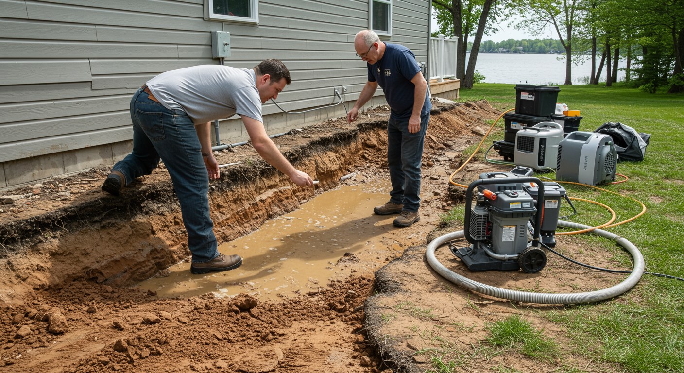
This is the most Chanhassen-specific water damage factor. Agricultural tile drainage — perforated pipes buried below the frost line to remove excess water from crop fields — was installed throughout the land that is now Chanhassen’s suburban grid. When suburban development replaced farmland in the 1980s and 1990s, those tile networks weren’t always properly abandoned or mapped. Some remain active under subdivision streets and yards. Others were intersected during construction and now dead-end, concentrating drainage in unintended locations.
Chanhassen’s clay-heavy soils compound the issue. Clay has high water-holding capacity — it drains slowly, retains moisture longer than sandy or loam soils, and creates hydrostatic pressure against foundations during extended wet periods. The city’s own drainage documentation specifically notes that clay and silt soils increase the likelihood of ponding and pooling. When a property sits on former farmland with clay soil above a legacy tile network, water behavior around the foundation is genuinely difficult to predict without knowing the drainage history of the site.
The practical result: Chanhassen basements sometimes flood in patterns that don’t match the standard burst-pipe or heavy-rain models. Water enters through floor-wall joints without a clear surface flooding explanation. Sump pits fill rapidly after rainfall stops, driven by tile drainage concentrating in the foundation drain rather than dispersing across the field it was designed for. These situations require someone who understands the agricultural drainage history of Chanhassen’s development pattern — not someone applying a generic basement flooding checklist.
Lotus Lake and Purgatory Creek: Chanhassen’s Highest-Risk Corridor
Lotus Lake feeds directly into Purgatory Creek — the same creek that produced the Burr Ridge Lane mudslide and demolition in Eden Prairie, and that the Riley-Purgatory-Bluff Creek Watershed District has classified as high-erosion-risk throughout its corridor. In Chanhassen, the connection between Lotus Lake and the creek system creates flood exposure for properties along Pleasant View Road and the lakeside neighborhoods of southern Chanhassen. The city has completed stormwater improvement projects on Pleasant View Road specifically to address erosion and overflow reaching Lotus Lake — documenting the active flood management challenge in this area.
Bluff Creek’s Chanhassen headwaters add a second corridor of elevated risk. As the origin point of the creek, Chanhassen receives no upstream drainage relief — all of the watershed’s accumulated runoff starts here. During extreme rainfall events, Bluff Creek’s upper reach in Chanhassen can exceed capacity, affecting properties along its channel and in the adjacent floodplain.
Frequently Asked Questions — Water Damage Restoration in Chanhassen, MN
Why do Chanhassen homes near Lotus Lake and Bluff Creek flood more frequently?
Lotus Lake feeds directly into Purgatory Creek, which is a high-risk-for-erosion system throughout its watershed. When Purgatory Creek’s capacity is overwhelmed upstream or at the lake outlet, water backs up and affects properties in the drainage corridor. Bluff Creek originates in Chanhassen — meaning the city is at the top of that watershed, accumulating drainage from the entire upstream area. Properties near both creeks have flood exposure tied to watershed-wide conditions, not just local rainfall on their lots.
What is tile drainage, and why does it matter for Chanhassen water damage?
Agricultural tile drainage is a network of perforated pipes buried below the frost line — originally installed on farmland to remove water from soil so fields could be planted earlier and stay productive longer. Much of Chanhassen was farmland before its suburban development wave in the 1980s and 1990s. Some of those tile drainage networks remain under the soil of subdivisions built over former fields. When a tile line is intersected by construction, blocked by root intrusion, or overwhelmed by heavy rainfall, water that would have drained through the tile system now surfaces in basements, yards, or foundations. Chanhassen’s city documentation specifically notes clay and silt soil with high water-holding capacity as a drainage concern throughout the city.
How do Chanhassen’s 356 wetlands affect water damage risk for homeowners?
Chanhassen’s wetlands function as natural water storage — they absorb overflow during wet periods and release it slowly. Properties adjacent to wetlands have groundwater that tracks wetland water levels. During extended wet periods, wetland levels rise and groundwater in adjacent soils rises with them, increasing moisture pressure against foundations. Chanhassen’s Surface Water Management Plan specifically addresses the challenge of protecting development from wetland hydrology while also protecting wetland function.
What are the most common water damage causes in Chanhassen’s suburban homes?
Sump pump failures during storm events are the leading cause, particularly in the lakeside and wetland-adjacent properties in the city’s southern and central areas near Powers Boulevard and Lake Ann. Frozen pipe bursts in Minnesota winters are the second-most common cause. Irrigation system failures — particularly supply line breaks at valve manifolds and controller failures that allow sprinkler heads to run continuously — are increasingly common in Chanhassen’s heavily landscaped suburban developments. And basement seepage from former agricultural tile drainage intersecting foundation drains is a unique Chanhassen issue that generic restoration companies often misdiagnose.
How quickly can Partners Restoration respond to water damage in Chanhassen?
Partners Restoration is based in Medina, approximately 10 to 15 minutes from most Chanhassen neighborhoods. We answer 24/7 at 952.500.2426.
Water damage in Chanhassen? Contact Partners Restoration. Based in Medina, 10 to 15 minutes from most Chanhassen neighborhoods. Call 952.500.2426 24/7.
Also see: Water damage restoration services in Chanhassen | All restoration and remodeling services in Chanhassen, MN | Insurance claims help
Leave A Comment